


SityTrail - Abbayie de Torronet

affinetataille
User GUIDE
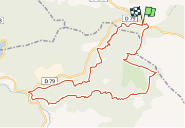

Length
12.3 km

Max alt
354 m

Uphill gradient
312 m
Km-Effort
16.5 km

Min alt
185 m

Downhill gradient
315 m
Boucle
Yes
Creation date :
2023-02-06 12:22:56.585
Updated on :
2023-02-15 09:50:07.298
6h00
Difficulty : Medium

FREE GPS app for hiking
 SityTrail
IGN / Geographical institutes
SityTrail Plus
The world is yours!
About
Trail Walking of 12.3 km to be discovered at Provence-Alpes-Côte d'Azur, Var, Le Thoronet. This trail is proposed by affinetataille.
Description
bien
Photos


28 photos in total. Please click on a photo to see them all in the gallery.
Positioning
Country:
France
Region :
Provence-Alpes-Côte d'Azur
Department/Province :
Var
Municipality :
Le Thoronet
Location:
Unknown
Start:(Dec)
Start:(UTM)
278427 ; 4815591 (32T) N.
Comments